Sunday, 23 September 2012

Mallaig & Isle of Skye

The first stop I made along the A830 was in Glenfinnan. Another stunning location with a lake, Loch Shiel, glens and a monument. The Glenfinnan Monument is to represent where Bonnie Prince Charlie had gained enough support from the Scottish clansmen to raise his standard. A kilted Highlander is situated on the top of the monument.
However, Glenfinnan is now popular for one of the film sites for the Harry Potter films. The viaduct is where the train "Hogwarts Express" tracks across two times a day. I just missed the train by five minutes as it was heading to Mallaig, but figured I could catch in on the way back in the afternoon. Can't come all the way here and not get a photo of the steam train on the most popular viaduct (with it's 21 arches) in the UK!
The drive to Mallaig was beautiful. It was one of my favourite drives so far. Mallaig was a small fishing village with brightly coloured houses and tourist shops. Very quaint. It's also the main ferry point to head over to Isle of Skye. But, I'm going to go the long way there by driving, to see more sites.
While backtracking, I stopped to have a picnic lunch at the Silver Sands of Morar. A stunning beach of... you guessed it, silver sand, that was so fine it was as soft as velvet. The water over the sand looked so tropical with the brilliant turquoise blue. So inviting, but the water was still cold. I soaked my feet in the ocean only for a short time. Didn't take too long for them to numb. But, with the sun popping out here and there between the clouds, I couldn't help but pretend I was somewhere warmer.
After a nice stroll on the beach, I diverted off the main road and took the narrow local road cutting through small villages and farmland.
I stopped at Arisaig and popped into the Land Sea and Island centre. Bit of information about the people's way of life in the local area back in the past and about the marine life. Good place to stretch the legs. Only a couple white painted buildings here with a cafe and hotel. Mostly just boats and beaches. A quiet place known for Bonnie Prince Charlie. This is where he fled to France to avoid capture from the government forces in 1746.
I headed back to Glenfinnan to be on time to watch the steam train. There's a lovely viewing point up a path behind the visitor centre. I'm glad I was 15 mins early. Two buses full of Asian tourists arrived, so I luckily had a good spot! Would've been a nightmare otherwise.
The train came around, puffing it's smoke and tooting it's horn. With the hills in the background, it really was pretty to see.
I continued on my way, stopping at Commando Memorial near Spean Bridge. It was in remembrance of WWII soldiers and had a nice view on Ben Nevis and Aonach Mor.
I stopped at a layby on the A87, overlooking Loch Garry and made some dinner. At least the rain held off until I turned my stove off. More rainbows came around. With the spot of sun, I could watch the rainbow get closer to me as I ate, looking out over the landscape. Since it was getting dark, I found a resting site off the main road on a loop road and slept in the car. A caravan had the same idea. The following morning, the lady came by to say hi and offer me a cup of tea or coffee. Such a nice couple!
Another day of driving ahead. Again, I made some pit stops along the way. Glen Sheil had fantastic scenery and a few battlegrounds. After passing the Five Sisters (nice chain of small mountains) I stopped at Loch Duich to see Eilean Donan Castle.
Eilean Donan Castle is named the most romantic and one of the iconic places in Scotland. From Vikings, to the Jacobites and then the MacRae family, this castle had been through a lot. The name is thought to come from an Irish Bishop named Donan from back in the 6th century. Eilean Donan means "island of Donan." But the castle itself wasn't built until the 13th century as a fortification against the Vikings to protect the town, Kintail.
The entrance of the castle talked about the Viking invasions and had a couple figureheads from their boats. Then, after walking around the outside and enjoying the calm water on the loch, I went inside.
I read about the history of the castle. Starting back to 1719, the castle was badly damaged from the Jacobite rising. Spanish soldiers were helping the Jacobites, waiting for weapons delivered from Spain, but the English Government learnt of this and sent 3 ships to bombard the castle. Since the castle wall help defend it, but the English went ashore, overran the soldiers, found over 300 barrels of gunpowder that they then used to blow up the remains of the fortress.
You could see many canon balls on display in various sizes. Some still being found in the water around the castle.
For 200 years it lay in ruin until a man bought the tiny island and began rebuilding it, following the original ground plan that survived. Once completed, the MacRae family moved in.
There were wax figurines in the scullery and kitchen to get the idea of their way of life. Even had original recipes you could go through. Food and china displayed as well. All kinds of furniture, paintings, clothes, maps, paintings, photos, war shrapnel and a few treasures found about in the mural chamber, bedrooms and great hall. Full of history. Their were guides dressed up in 20th century clothes able to tell stories and answer any questions you may have. They were brilliant. A place worth visiting. The large Banquet Hall was my favourite. Stunning with the large fireplace and Victorian style setting. The wooden timber beams is actually Douglas Fir from BC, Canada.
The gift shop and cafe was worth popping into as well with an alluring smell of food.
After my visit, I popped into an outdoor store in Dornie to buy a rain cover for my daypack. I talked with the man behind the counter and he recommended I take a drive down the little road to Sallachy. Beautiful and good hiking, he said. I figured, why not? Always nice to venture on those small little roads for a look see.
The water was very calm in through here. Nice local homes surrounded by great hills. Very picturesque and great place for my lunch.
Kyle of Lochalsh wasn't far from there, and I went into the visitor centre to take a look at some hiking maps for Isle of Skye and roamed around the village for a bit. Picked up some groceries, and then over the bridge to the Isle.
I headed north on the island up to Portree. There, I camped at Torvaig Campsite, just north of town. It was nice and flat with well kept grass for pitching. The owner was very friendly and after talking with him about the hikes I was hoping to go on, he agreed to check in on me at the end of the next day to make sure I arrived back ok.
The next morning, I drove to the car park for The Storr. It was an easy walk to the oddly shaped rock pinnacles. The most prominent pinnacle is the Old Man of Storr. I then continued to a barbed wire fence. There was a section to cross and I walked along the path around the ridge to eventually ascend to the top. What a great view of Trotternish Ridge. Good area for expedition hikes. Though there were many paths that branched off along the ridge, not all were safe. Many paths were unstable terrain. I stuck to the middle of the ridge to the summit of The Storr, then back tracked the way I came.

Next, I made a pit stop at a viewpoint to see Kilt Rock. The cliff had a neat pattern to it. The basalt rocks formed vertical columns. Kind of made a pleated look, resembling a kilt. Hence the name of the cliffs. Mealt waterfall situated before Kilt Rock, falling the 170ft to the pebbled base. Made it a fantastic site.
On to my next hiking destination to the north on the isle. The 7km circuit of the Quiraing. I followed the trail along the bottom of the ridge. Some parts got quite narrow and was a bit slippery from all the mud and rain. But seeing the view from the rocky gully was amazing. Up to more needle pointed pinnacles, I took a look around at my trail options. I could scramble over the loose rocks that had fallen in landslides and avalanches that most people take... or climb up and around one of the pinnacles. I decided to climb (rather than risk twisting my ankle on all those slippery rocks).
Up and half way around the pinnacle, the very narrow path stopped. I had a choice of climbing or going back. Without looking down, I thought, let's climb! Many rock climbers come here to tackle these various shaped rocks. I didn't have any trouble finding good foot grooves and natural handholds. I was able to boulder my way around to the other side. Once I mad it back to the path again, I looked at what I crossed. Though it wasn't far, I thought "What an idiot! What was I thinking! It's a long way down, and if I slipped I would have landed on jagged pointed rocks! How reckless!" Whew, after berating myself and telling myself NOT to do something like that again (at least, not without climbing gear, ha ha) .
I continued along, curving around to a section that was more grassy and boggy. Down came the rain! Big cloud came round and I was soaked to the bone. Luckily, the strong wind kept it moving and within 20 mins, the sun appeared again. At the end of the point, I ascended up the winding path that then slowly climbed the ridge. Easy walking along the grass up at the top. Many sheep here and there and a constant panoramic view of the sea and Totternish peninsula. Once I got to the part where I had to descend the summit, the path followed the edge of a very steep slope, zig zagging here and there. It was nerve wracking. So muddy and steep! And a long way down if you start to slide down. I accepted that it was very likely I would slip and fall on my butt. I was happy that I had a couple behind me, just in case I did take a tumble, and relief that my campsite knew where I was.
Luckily, I didn't slip once! Even at the end where it was the steepest. I did my best to stay on the bedrock to avoid the mud and wet grass. Just never know when the grass bed will crumble, as there's not much there anchoring it.
I was happy to get back to the car and warm up. A little mobile coffee stand was at the car park and I gratefully had a tea to try to warm up. It was so cold! Didn't help that I was fairly wet. I chatted with a cyclist that joined me for tea, then headed back to camp to check in, have a hot shower and dinner, followed by a much needed rest.
I was freezing the following morning. It had fallen below zero during the night and I had ice all over the fly of my tent. Could've used a winter tent. I packed up quickly and got moving to warm up as fast as I could. Then I drove back through the Quiraing again (it was so pretty) to Uig, and followed the road along the coast to Dunvegan. There, I went to Claigan Coral Beach.
Only about a 2km walk to the beach, and it's worth it! It looked very tropical with the sun shining on it. The black basalt rocks eventually gave way to a white sandy looking area that was actually composed of sun-bleached seaweed called maerl. Maerl grows slowly (about 1mm/year) and lives a very long time. It grows unattached on the sea floor, forming balls like tumbleweeds in areas with strong currents. It's enriched with lime so it was used by farmers in the past as fertiliser. The Maerl beds create a great ecosystem for a variety of marine life. So, it's not uncommon to seal seals nearby.
All along the beach were multicoloured shells. I have never seen such yellow and orange snail shells. It was beautiful. Looking into the water, red jellyfish were scattered everywhere. Some getting caught up on the rocks from the tide forcing them too far to the shallows and shore. So much life here.
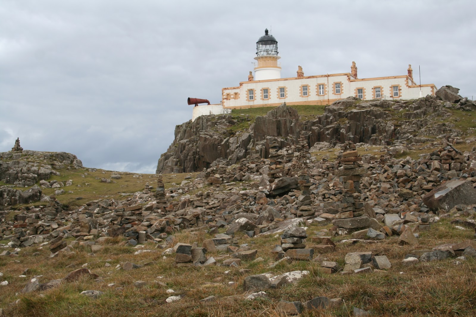
Next, I went to Neist Point in the Duirinish peninsula. The lighthouse here was dated from 1909. Nice red foghorn stood out amongst the white and yellow building. Can also see the old cable way that was once used to transfer supplies to the cottages and lighthouse from the end of the public road. Nice viewpoint to watch for seals and whales. None that day though. Too windy to see anything amongst the waves.
I drove the main road south to Kinloch forest and camped out here for the night. I woke this morning, excited to continue down to Armadale, to see the castle ruin and museum of Clan Donald. The clan my grandma's ancestors branch from.
Armadale castle was on a huge estate with tons of walking paths in the woodland and beautiful gardens. Some of the trees reminded me of home with all the multicolours of autumn. I visited the castle ruin first. It was built in the 1700's, but in the mid 1800's was destroyed by a fire and abandoned. Plants were growing on the walls and though some of the medieval stones could be seen on the ground, it was mostly all vegetation. It was really pretty, seeing nature take over that place. To the right side were estate offices, attached to the last wall of the ruin. Looking through the windows, I could see paperwork and coffee cups. Ha ha, yup, just looked like office space. Not too exciting.
Next I took advantage of the sunlight and walked around the gardens. Looking at the ponds and an old stone walled ruin where they did the laundry.
Lastly, I visited the Museum of the Isles. There was a library inside, where you could meet with someone who would help research your ancestors by using genealogy. That was really neat.
There were 6 galleries following 1500 years of history and culture of Clan Donald (the Lords of the Isles), the highlands and kingdom of the isles.
It tells of the origin of Clan Donald. Started by Donald, the grandson of Somerled (a Gaelic hero), who then named his decedents and followers MacDonald. Clan Donald is one of the largest clans of Scotland. It was a very powerful clan in its time. I learned of the battles between clans and land (looked like the Campbell clan and Donald clan really didn't get along), the Jacobite rising and falling, the English government forces impact on the clan, the tragedies, struggles and bloodshed of the people and the loss of homes through evictions, resulting in immigration to other countries.
I think the most horrific story was the massacre of Glencoe in 1692.
William, prince of Orange, was invited to take the throne, and had offered the Highland clans a pardon for their involvement in the Jacobite uprisings if they took an oath of allegiance in front of a magistrate by a certain deadline. At the time, James II of England was exiled in France and was hoping to return to reclaim the throne. The Highland clans awaited his permission to give their oath to William. Finally, James had given them permission and the clans gave their oaths. But, the message was sent in winter, when the weather was in bad conditions and was received by the chiefs only weeks before the deadline.
Some chiefs promptly gave their oaths, others didn't. The chief of Glencoe, Alastair Maclain, was one of them. He first went to Fort William, but was told the governor wasn't authorised to receive it. Given a letter of protection and a letter to receive the oath as he came to the governor in the allocated time, he went to Inverary. Winter weather slowed him down and he also was detained at a castle (as a ruse to delay him). Once in Inverary, he had to wait for the magistrate to return from a family visit for 3 days. Finally, he gave the oath, thinking all was well.
However, a senior member of the Campbell clan saw Maclain was late giving his oath and took advantage of that knowledge.Wanting to seek revenge on the clan, he found an accomplice (who wanted the downfall of the Highland clans), Master of Stair, to take them down. The Master of Stair persuaded William to sign an order to exterminate the MacDonalds of Glencoe by telling him of the irregularity of the oath, and that it's to rid the thieves in the valley.
A regiment of 120 men went to Glencoe. The Highlanders believed they were there to collect tax and the soldiers received the hospitable tradition of the Highlands. Unknowing of the real orders behind the visit.
38 men were murdered either in their homes (as Maclain was, in his bed) or trying to flee the valley. The woman and children were able to escape, but many died of exposure after their homes were burned. Some of the soldiers didn't agree with their orders and had either warned the people or refused to act. Such a sad story.
So much to take in, all the history of the highlands. But, I enjoyed learning, even if some of the stories were devastating.
Now, I'm back in Kyle of Lochalsh treating myself to lunch. Next, I'll be heading north to Torridon. A place recommended by some other hikers I've bumped into.

Wednesday, 19 September 2012

Glencoe & Fort William

The drive to Glencoe was lovely. I followed the coastal highway and passed a few rainbows along the way. Yes, it was raining. Again. But, at least the sun tried to make an appearance and as a result... rainbows!
As soon as I reached Ballachulish, I could see the change in landscape. Lush green rolling hills a plenty. Within 10 minutes, I was in Glencoe. I stopped at the visitor centre to pick up a couple walking maps then headed out.
I stopped at almost every layby, taking pictures and enjoying the scenery. What a gorgeous place. I fell in love with it. Even though it was dark, cold and raining, the beauty was overwhelming. Waterfalls all over the mountains and roaring streams from all the rain. This is the benefit of being here in autumn. The downside... very slippery and boggy while hiking.
There were many parking areas along the A82, and I stopped at one of the main ones. At The Three Sisters. 3 peaks beside one another, with deep valleys in between them. I got geared up to brace the cold, gusty rain and started on my hike. The valley I chose was between the last peak of the Three Sisters and Buchaille Etive Beag. It was full of little streams, lots of purple heather, tall green grass, moss and bunches of bracken. This is Scottish muirs. Such a beautiful site. I love all the purple heather, and occasional yellow and white flowers. Seeing that scattered over the rich variety of greens, can't help but tug at your heart. I didn't mind being soaked at all.
I followed the trail into the valley, then decided to skirt off up the mountain. It was extremely windy. The mountain had 2 summits (924m and 958m) and I hiked up in between them. I debated climbing the last 150 m to the top but thought, with all the gust I'd get up there, it would be very dangerous. I had the occasional gale almost knock me over as it was, sheltered in the rocks. So, I just enjoyed my view there and eventually made my way back to the car. I made a few more stops along the way and then looked for a place to camp for the night.
There was a small road that headed toward Glen Etive and I drove down there. It was a small, windy road but had lots of passing areas for other oncoming vehicles along the way. It wasn't a very busy road so I took the opportunity to take many pictures at most passing bays. Such a nice place. A river roaring alongside the road through the valley with Buchaille Etive Mor on my right side. A pyramid looking mountain. Passed a few areas with Red deer as well. Many bucks, and only 3 doe seen so far. Their quite large, those deer. Beautiful.
At the end of the road, there was a little gravel parking area and then a nice couple patches of grassy areas beyond it, perfect for setting up a tent. Right along the loch shore. The loch connects to the sea from here, so it wasn't good for washing. But it was no bother. Plenty of fresh water streams and waterfalls around. I was fairly sheltered at my camp, surrounded by mountains. Not much wind and it was so calm and quite. I had it all to myself. I set myself up and roamed around the area a while. After I had my dinner, another vehicle showed up. Three men had the same idea and they set up their tents not far from mine. I thought, why not say hello? It's just us 4 for the night...
I introduced myself and I met Sinclair, John and Russell. Sinclair and John lived in Edinburgh , while Russell was from Sheffield in England. They were having a weekend away from the city. They were very kind to me, offering me to join them for dinner and wine. I had already ate, but seeing how they had meat (and burgers at that!), how could I resist. My fruit and cracker dinner didn't compare to that!
We sat around the campfire and drank wine, sharing stories. Next thing you know, we drank all 3 boxes of wine and even a bottle of whiskey Sinclair had for a little nightcap. Ha ha ha, all 4 of us were a bit drunk, I have to say. We felt like a bunch of teenagers being so silly, stumbling around, even tripping over the fire! Oh dear. We had a blast though. Those guys were awesome!
I woke up the next morning sick as a dog. I don't like wine at all, and to drink that much the night before... *groan*. When I got out of my tent to see them, John had gone for a wander and Sinclair was looking not much better than me sitting in the chair. Ha ha, what a sight we were. Russell was walking around filming a bit, but he wasn't top shape either. We laughed at ourselves, reliving some of the moments of the night before, and the boys were thinking "we drank all our alcohol for the weekend on one night!" Not what they had originally planned! Lol, but they had a great time too. I stuck around for a short while when John came back from his walk, exchanged numbers and emails and then I headed off.
I planned to do some more hiking, but with the way I was feeling... As I said, the road was windy. Had to stop 3 times to be sick then decided to pull over and have a little nap to get the nausea to subside a bit. After an hour, I was feeling much better, and wanted nothing more than I nice warm shower. I drove to Red Squirrel Campsite and got a pitch there. I did some laundry and the nice European staff allowed me to hang it up in a washroom that was currently closed off. Was perfect. I got some directions for a hike nearby and planned to go up it the following day before I moved on. Seeing how I was in poor shape, I just napped, read my book, did a small walk, drove around here and there, and socialized with the campers beside me before calling it a night. Suited me fine. A few midges were out and about anyway, being near the river's edge.
After packing up the following morning, I went to hike up the Pap of Glencoe. As per the directions, I was to follow the trail, pass through 2 gates then go up a steep trail after crossing 2 streams. The path I was on was a logging road, that I had to veer off and cut through a wooded area up onto another logging road. Problem was, I didn't know if I should go left or right once out of the trees. My gut said right, as it went uphill, but I was curious what was left. Of course, my curiosity got the better of me and I went left. Not much to see really, but it did lead down toward Loch Leven. Wasn't long before I turned around. I found the trail that cut through my first gate, trudged through lots of mud, puddles and bog (trying to walk on the rocks I could find as some areas were deep) and then came to gate number 2. Great, now I just had to find the trail going up the mount. And I walked, and walked... and am I all around to the other side of it now? Where the heck is this trail after the 2 streams? There's streams everywhere!  The path I was on does go all the way around the hill, following power lines. But I didn't want to keep going on this path. I resolved and headed back. Once near the gate, I looked again for this trail. I've wasted so much time already... but, where the heck was it?! Then I realized, the trail was a waterfall. All the rain over the past month, had flooded the trail. Lol, I wasn't going to go up that! So, I figured I'd start my way to Fort William as I was bound to find somewhere else to hike.
And that I did. I took the loop to Kinlochleven and found a Greymare's Tail Waterfall trail (named after King Edward VII horse). I know what your thinking... really, another waterfall Vicky? Haven't you seen enough? But hey, why not?
As I followed the colour marked path, I ended up finding multiple trails forking in different directions. I picked one. Ended up climbing and came out in a stunning glen, full of flowers, heather, sunshine and a beautiful view of Loch Leven.
Sometimes, it's worth getting a bit lost. I hadn't seen this waterfall, but I found something beautiful all the same. On my way back down however, I did find the waterfall. Wasn't as grand as I was hoping, but the forest was really pretty.
Wasn't long before I arrived in Fort William. The town is quite small, mostly outdoor stores, a tesco (groceries), pubs and hotels. A few tourist shops and a visitor centre. About it really. Very small, but it was great! All the outdoor stores had sales! Had to look around. Fort William is popular because it's the end point of the West Highland Way trail, as well as the entrance to the biggest mount in the UK, Ben Nevis.
I then drove to the end of Glen Nevis, enjoying the landscape around me. The very end of the road had a little car park and I decided to sleep there in the car overnight. About 4 other people were doing the same. To soggy of a ground for a tent here. I slept quite comfortably in the front passenger seat. Amazing how you can adapt.
The following morning, I decided to walk the trail to Steall Waterfall. Regardless of the pouring rain. And the trail wasn't without a few obstacles. Some parts of the path, you would step across rocks over a stream... but the streams were rampant down the slopes, the rocks slippery and some even under the fast flowing rapids. I was very glad to have good boots and sure footing. Yes, I said sure footing. I'm not always clumsy. Only sometimes.
Once I got to the meadow, it was completely flooded. The path I was supposed to follow was thigh deep under water. I scrambled along the side of the hill amongst the vegetation. Nice thing about the heather, it forms a solid foothold.
The waterfall was beautiful. Finally! A true waterfall! Not just a small one from all the rain, but one with some height and width. A hut was on the other side of the river, but seeing how all there was to cross the river was a metal wire to balance on and two as railings, I figured I wouldn't even try with how slippery it was and with the roaring river. Wouldn't risk my camera getting wet ;)
A path also follows along the river and eventually would cross it to the Steal ruin, but I'd have to come back another time when the water level is lower.
Next, I drove to Braveheart Carpark to hike up Cow Hill. It's just under 300 m (almost 3 km walk), but would be enough to still have a nice view.
The walk up was an easy one, and more of the heather moorland at the top. So pretty. Unfortunately, the clouds were too low to see the mountain tops, so I didn't linger too long up there given how wet I was. The wind picked up a bit and I was starting to get chilled from being soaked to the bone for hours. So, I headed back down to the car park and made myself some soup there at the picnic table.
Next, I went to the visitor centre for hiking Ben Nevis. I bought a proper map and guide for the mountain and checked the weather forecast for the next day. It was going to be sunny in the morning, then rain in the afternoon. Lightening storm up at the summit in the evenings with a possibility of snow. So, I planned to head up first thing in the morning. I was hoping they would have a form I could fill out to let them know if I went hiking and they could check to make sure I returned ok (like when I was in Australia), but no such luck.
I decided to stay at Glen Nevis Caravan and Camping Park. Again, no buddy system there, but it was a big campsite. At least they had showers. I would need it for after my hike the next day. I settled in, made dinner and had an early night.
Next morning, I got up early to catch the sun. And it was a lovely day! So nice to have some dry weather. Many people were already starting the climb by 7:45 am. Off I went to join them along the Pony Track. The first 600m was easy going, climbing up the Red Burn valley. It levelled off a bit at this half way point, revealing a small loch (called Lochan Meall an t-Suidhe) with a bunch of Red Deer nearby. Superb views of the valley.
From here on, the path relentlessly climbs a zig-zag pattern through scree and around boulders to the peak. By 800m, snow was dusting the rocks. The higher I went, the more snow there was. Luckily, it didn't get very deep. It has been known for hikers to loose the path and end up getting too close to the peak's edges leading to fatalities. Especially along the Five Finger Gully.
The summit plateau flattened out a bit, much to my relief as I pushed through my wall already and was wearing out. At the summit proper, there was a metal hut, war memorial and a ruin of an old meteorology observatory from the late 19th century. The question I had, "why is the hut on the highest point in the UK made of metal?" Lightening storms are not uncommon up here and people use the hut as a shelter. Even to sleep in sometimes. However, I guess if you're daft enough to sleep in a metal conductor during a lightening storm...
I didn't stay too long at the summit. There was thick fog and low cloud so no view at all. Visibility was only about 150 m. I stayed long enough to have a snack in the hut, talk to a few people, then headed back down as I was sweaty and getting cold with the brisk wind.
The descent was easy going. Enough people had walked to the summit that you could just follow the trail of footprints in the snow until the path was obvious again. Funny, sometimes, coming down hill is more difficult than going up. My knees and legs were getting pretty tired of the descent.
On average, it takes 6-8 hours to climb the 17km height of 1344m. I did it in 6.5 hours. I was very proud of myself. And rewarded myself with a hot shower, warm soup dinner and a good read before falling into a blissful sleep.
Today, I plan to have a nice coastal drive to Mallaig before heading to Isle of Skye. Let my sore body rest!

Friday, 14 September 2012

Oban & Isle of Mull

After looking around town for parking, I found free parking in a lot by the recreational sports centre. It was up on the hill from town, but I didn't mind. One of the first sites I was going to look at was up on the hill anyway. McCaig's Tower.
The tower was built in tribute to the McCaig family. There was a beautiful, well maintained garden inside and a great view overlooking the fishing village of Oban and the islands off in the distance. It was very quiet up there and I took a half hour just enjoying the peace. I loved seeing the ocean. And I knew I was lucky, as the sun had made an appearance. According to the locals, that can be a rare thing in this seaside town.
I made my way down into the village to wander the shops. Got a local map from the info centre for orientation. Of course, one of the first stops I did was to go into the chocolate factory. Had to buy a few to try. Hmmmm, and they were good.
I walked along the esplanade to Dunollie Castle. This castle was dated back to the 15th century and built by the MacDougall clan. It has long since been abandoned for Dunollie house just downhill from the ruins. It used to be bigger than what is now seen. There were 3 floors, a dungeon (which hasn't been found) a chapel and 2 great halls. A settlement of people would have lived surrounding the castle, tending crops, net fishing in the sea, tending cattle and fighting for the chief when needed. The 5th chief, John of Lorn, was a supporter of King Edward II against Robert the Bruce and as a result, did have the castle besieged. So, the castle had been restored a couple times.
I headed back into town, bought an adaptor to charge my electronics and batteries with the car's lighter socket, had lunch and then made my booking for a tour the next day on the Isle of Mull.
Instead of staying at the campsite, I drove south out of town and found a nice resting site along Loch Feochan. I made dinner and decided this would be a good place to wild camp. There was fresh water running into the inlet so I could use that for washing up. Worked for me. Also was able to find a few spots along the shore to sit and look out on the water.
The next morning, I parked my car at the rec centre again, and went to catch the Caledonian MacBrayne ferry over to Craignure on the Isle of Mull. I was picked up at the pier by my tour with Isle of Mull Wildlife Expeditions. My guide was an ornithologist (bird specialist) and had been running tours on Mull for many years. We had a comfortable van and more then enough binoculars to go around for wildlife watching.
We hadn't driven far along the Sound of Mull before finding about a dozen porpoise frolicking out in the bay. I've never seen so many together at a time. They are usually in smaller numbers. A great sight to see. Our guide, David Woodhouse, identified a bunch of sea birds and tried to explain to us how to tell the difference between a Shag and a Cormorant out at a distance. The Shag is slimmer and when it dives, it clears the water where the Cormorant only half clears it. Doesn't look quite as graceful. After watching a few out on the rocks, I could see what he meant. Sure wouldn't have picked that up on my own... takes a trained eye.
We then continued along the coast until David spotted an otter. A coastal otter. The coastal otter is the same species as the freshwater otters inland. Main difference (besides the obvious, one in the sea, the other in fresh water) is that the coastal otters are up and about during the day. The freshwater otters are more nocturnal. The sea otter in North America is a different specie all together.
Hmmm, so maybe I did hear otters in the river by my tent the other night in the Trossachs...
The otter was diving about and catching all kinds of things just off shore in the kelp beds. We were all excited to see him come ashore, shake himself off, eat a fish and groom before he scurried off for cover. Cut little fella.
We continued driving, keeping our eyes open but also enjoying the gorgeous views of all the valleys, rivers, coastline, craigs, waterfalls and wooded areas. We saw a few seals lazing on some rocks and 4 White-Tailed Sea Eagles. Two adults were resting on a tree branch and two juveniles were circling in the air. Saw many buzzards as well. But they weren't as impressive as the eagles.
David said we were very lucky to see 4, as they aren't as commonly spotted. He mentioned the best time to see birds of prey is after a rainfall and that they tend to fly against the wind. Using the wind to keep them stationary in the air for a good look around. Also, key spots to find the eagles were tree tops (well, duh) and up on craigs sheltered by the wind. No Golden eagles for us that day, but that's alright. Maybe next time.
Along the main roads through the mountains, we had a great panoramic view of 3 lochs in a glen. It really is a pretty island. So much to see.
The food on our tour was great as well. Homemade soup and sandwiches, with cake, tea, coffee and biscuits. I believe our guide said his wife made the food. Even though I was much younger than everyone in the group, we all got along well and I really enjoyed my time. David dropped me back off at the pier so I could catch the 5 pm ferry back to Oban. Once I arrived on the other side, I grabbed a sandwich for dinner and drove back to the same spot I spent the night before at Loch Feochan.
This morning, I head off to Glencoe. Looking forward to seeing this place, as it's been raved about!

Wednesday, 12 September 2012

Trossachs & Loch Lomond

After picking up my rental car from Enterprise, I navigated my way out of the city and headed to Stirling. I figured this would be a great place to pick up some groceries and have a break from driving. Always good to get orientated with backward driving! Ha ha.
I was actually quite comfortable behind the wheel. No problems with the roundabouts.
I parked up by Stirling castle and had a stretch. On my way up to the castle, there were a few sites. The Old Town Jail, the Church of the Holy Rude (which had a lovely cemetery with lots of large headstones) and Argyll's Lodging. This lodge was a mansion made into a 17th century townhouse to entertain royalty by William Alexander whom helped found Nova Scotia in Canada. On the shield above the entrance had a mermaid, Native American and a beaver. Yes, Canada has made it's mark! It was the first respresentation of the beaver on a coat of arms.
I walked to the castle and checked out the Robert the Bruce Statue (the national hero who won Scotland's freedom) and admired the view of the town and countryside. I could see the Wallace Monument up on a hill, but figured that and the castle will have to keep for another day. I was ready to get going and see some nature. I headed back into town and popped over to Tesco to get groceries, then was off.
I drove to Gartmore and got a pitch at Cobleland campsite. The people in the office were extremely friendly and helpful. They gave me their recommendations on what to see and gave me a free walking map. I decided to stay 2 nights and as I would be hiking alone, they were more than happy to check in on me every evening to make sure I made it back to camp safely. We exchanged mobile numbers so I could message them my location as I jumped from place to place. They were wonderful!
I tried to pick the highest ground along the river and set up my tent. From there, I walked around the area. Looked at a neat little country house with a medieval looking gate, tromped though the wooded area in behind it, called Butler's Walk, talked to some locals out walking their dog, and walked along the river near camp.
The next morning, I drove out to Aberfoyle where I went to David Marshall Lodge Visitor Centre. They have zip lining here, but I just wanted to hike around a little and see the waterfall. They had many posts along Waterfall Trail with facts about the flora and fauna around the forest. It was a nice start to the morning.
I then headed to Ben A'an. A nice easy forest walk up to the top. Once in the clearing of the summit, heather covered the craigs, leaving a warm purple covering over the rocks and soil. Ben A'an is one of the shorter hikes, being 461m, but I still had a great view of Loch Katrine. I was fortunate to have dry weather. Cloudy, of course... but dry. I met a nice lady on the way up and after we rested we hiked back down together. Near the car park is a lavish hotel where she was staying and offered me a cup of tea. Which I gladly accepted. She had what was more like a flat on the ground floor. A good thing as our boots were muddy and we could leave them outside her sliding glass door.
After a short visit, I drove to my next destination back in Aberfoyle. From the Milton car park, I did the 3kms Lochan Spling trail. A loop around a small lake. The moss here was very colourful. Not just green, but a rainbow of green, yellow, red and brown. It was really quite eye catching. Many different kinds of mushrooms as well with all the moisture. Even found a neat little caterpillar crossing the trail and pike fish in the lake jumping to catch bugs. I thought I spotted an osprey, but I had some cyclists come by and the bird flew off, so I wasn't sure. Ach well, maybe next time.
I did plan on heading back to camp after those 3 walks... but seeing how I was already here, I figured... Why not one more walk? So, I did a 6kms walk along Ghleannain Loch trail. The trail follows along Loch Ard before turning away and heading into forested area and a small lake called Lochan a' Ghleannain. Man, was I ever tired after that walk! What was I thinking...
After making some dinner and a much needed shower, I fell asleep pretty quickly. I woke during the night for a bathroom break (why is it that you always have to go while camping, but can sleep through the night fine when indoors?), and it was really raining down hard. I put on my sandals and hopped out of my tent. As soon as I was walking behind my tent, I stepped in a huge puddle. Ankle deep! I switched on my headlamp to take a look around. Was I ever glad I picked a higher level of gound for my tent! The whole grassy area from the back of my tent on was a small pond. The water actually went up under my tent a bit, but luckily was only about 2.5 cm deep. Well, looked like my tent was being put to the test on it's waterproof flooring. I just had to wait until the morning to see if I awoke wet and cold.
I could hear a lot of splashing around in front of my tent as well. I faced the river and I wondered if the local fresh water otters were playing around.
Fortunately, all my research for my camping gear paid off, and I was bone dry. I was very happy with my tent. No water inside. I was glad to pack up my stuff however. Another night of rainfall like that, and I would be swimming in my tent. The water level would just be too high and would meet the mesh lining.
Once all packed up, I went for another stroll but near the campsite. I took the Fairy Knowe trail following along the river. It was a nice flat trail, so relaxing. Good way to wake up. I then went up Doon Hill to see all the tributes people had left for the fairies. Some of the Scottish people believe in fairy culture. Believed that the fairies would take your loved ones who passed on to this hill, where their spirits would be set free with the fairies in the afterlife.
At the top on the hill, all kinds of trinkets and ribbons were tied to the trees with blessings, wishes or in remembrance of someone. A man had just finished his commune with the fairies, and he had a spare ribbon that he gave to me to tie to a tree. That was very kind of him. We talked a little, and then he left to give me my space for my remembrance offering. I picked the largest tree to tie my ribbon on. Thinking of my family's recent losses of grandpa and aunty Ann. I wished for their peace and happiness where ever they may be and that they'd be together.
I read some on the other ribbons as well. People wishing for a baby, for a loved one's health, a little girl wished for a dog, people wishing for help for starving children, true love and happiness, etc. It was touching.
I soon headed back to camp, said goodbye to the staff at reception, whom were so caring, and drove to Loch Lomond. Queen Elizabeth Forest Park has free camping restrictions. Due to it's close proximity to Glasgow, the park has a lot of people coming up for the weekends who trash the place. Leaving garbage and liqueur bottles lying around and cutting trees for wood burning. Some don't use proper fire pits and burn too much around wooded areas so a bylaw was passed that no wild camping was permitted in certain boundaries of the park. Shame that people behave that way. You come out to places like this to get away from the city... not to bring the chaos of what you see in a city to nature.
As a result, I went to the information office and booked one night at Sallochy. It was the cheapest place I could find at £5 a night.
Once I arrived, I picked a lakeside site and put up my tent. A few midges were about, but they didn't bother me too much. Only if I stayed still for too long, then they'd bite me. They're awfully tiny, but do leave a good bite. But again, after having the mango rash, I didn't find their bites very itchy at all.
I found the wooded area much prettier around this area than in the Trossachs. There were many hiking trails, including one following along the east side of the lake, but my throat was a bit sore and my body was very tired. I did a lot of walking the day before so I listened to my body and just rested. Enjoyed the peace and quiet, walked around the beach and went to bed early.
The next morning was lovely. The clouds cleared up and the sun came out. It was fairly windy, so clouds came and went quickly allowing the sun to shine. I was feeling more rested and looking forward to my hike up Conic Hill. I packed up, ate breakfast and drove back to the info centre to park. I popped into the centre to make sure I took the right direction to Conic Hill and asked the rangers if they could be my buddies. Always good to have someone know where you are when hiking alone. I told them I'd only be about 1-2 hours and they were happy to watch out for my return.
It wasn't a difficult walk, but it was very muddy, slippery and windy so I was careful. And what a sight to behold once at the top! A fantastic panoramic view of Loch Lomond and it's surrounding woodlands. I would have loved to have a picnic up there, but with that cool gusty wind so strong, it was best to have lunch elsewhere.
I popped back into the centre to chat up the rangers and let them know I was safe. One, named Dougie, was very friendly and we exchanged numbers. He said he'd like to keep up with me on my journey in Scotland and maybe at some point, he could meet me somewhere and go on a hike together. At the very least, I made a new friend, so I thought it was a great idea. I hopped back into my car and started my drive to Oban at the coast. I drove along the west side of Loch Lomond to Tarbet, where I had a stretch and ate lunch.
Then decided to go west to Inveraray. The view driving along the outskirts of Argyll Forest Park was gorgeous! I loved the green valley. I had to pull over in a rest stop to enjoy it. Just couldn't pass the view up. I had a feeling this was gong to happen a lot on my upcoming journey.
And indeed, I made another stop in Inveraray to look at Inveraray castle. Argyll is Clan Campbell domain, and the Duke of Argyll has had his seat here since the 17th century. I didn't go inside, but this Neo-Gothic building was stunning.

While passing through Loch Awe, I made a pit stop at St. Conan's Kirk. It's a church of Scotland and is situated on a craig above the loch surrounded by trees, ivy and flowers. It was very peaceful and I really like the designs carved into the stones on the outside.
I arrived into Oban soon after. I drove to Oban Caravan & Camping Park and booked a night there. I needed to do some laundry and figured this would be a good place to do it. The campsite was up on a hill beside the ocean shore. Lovely spot. I picked a spot for my tent that had part of the hill blocking the wind and pitched my tent. Seeing how it was time for dinner, I ate, charged my batteries up then went to bed early.
This morning, I hand washed all my laundry, hung it up in the car and am going to spend the day exploring this seaside town my grandmother was from.

Saturday, 8 September 2012

Petersfield & Edinburgh

I was the first live-in carer my new client has had, as she was new to the agency. Numerous things to work out since no one really knew what she really needed. The town of Petersfield was small, but picturesque. My favourite spot was the lake. A walking trail circled around, then headed up behind to a wooded area and grassy fields. It was perfect for running. There was a children's playground and a small beach hut where one could hire a canoe or rowboat to putter around the lake. It cost £3 for 1 hour. Inexpensive and a great way to relax in the sunshine watching all the ducks, geese and swans.
I spent most of my break time walking around the lake, following some of the public right of way trails (these trails go all around the country, allowing people to walk through farmer's fields, around water channels, parks, etc. freely) and going on a few drives into other nearby villages with my client's neighbours, Sue and Allen. See, all the neighbours were elder woman and Allen took it upon himself to watch over all the old ladies. He was very social and we became friends quickly. When his wife had days off, she happily offered to take me to different places to get a change of scenery. Sue was a fountain of knowledge, knowing so much history of England. She was gifted with a photographic memory and remembered everything she has learned throughout her life. I was in awe of such genius. Both of them were also members of the National Trust, so she made great effort to learn the history of towns, rail lines, parks and heritage properties.
She drove me to the South Downs National Park trail (South Downs Way) which follows a chalk ridge all the way to the ocean. We went for a short walk up on the hill to enjoy the view overlooking the countryside.
Went to Alresford, which is a lovely Georgian town, to see the watercress farming. We walked along the river path to a beautiful house called the Fulling Mill and had tea at her favourite cafe. The steam train ran from here to Alton, delivering watercress to other locations. There was a Thomas the engine from the children books and TV show modelled outside the station. Brought back memories of when my brother was little, watching the show.
Another place we visited was the Grange at Northington. An estate formally owned by Henry Drummond (a wealthy banker) and now part of the English Heritage. It was once a country house that underwent a huge transformation in the 19th century to have more classical Greek design. The conservatory, over time, became a ballroom and now is a theatre built by the Opera house. They have opera evenings here outside in the summers.
Next was Winchester to see the castle. The castle is small with mostly just the Great Hall where you can see a round table dated from the 13th century, painted with King Arthur and the names of the legendary knights around it. It's displayed up high on the wall. There's also a small garden in the back to wander in. Winchester Cathedral is one of the longest in Europe and, as most of the cathedrals, had a spectacular decorative facade.
Then Bosham, a little coastal village known for it's sailing. The tide was out while we walked around the inlet, admiring some of the sailboats. We could really smell the seaweed. Also poked around in the Holy Trinity Church which still had architecture from the 800's. Had that basement smell to it. Old, musty and damp... I actually like that smell. Weird, I know.
Lastly Selborne, where we walked up a hill for a nice view. Continued on and roamed the 12th century St Mary's church grounds (where we saw a ton of bees, yikes!) and they showed me Gilbert White's Field Studies Centre. Unfortunately it was closed, but that didn't stop Sue from educating me. Gilbert White was a naturalist and ornithologist (bird specialist). He was recognized as one of the first ecologists and he made discoveries of the plants, animals and local birds. Such as bird migration. He used observation instead of specimens and was able to differentiate between similar looking birds by their song.
After 6 weeks with my client, I took a much needed break. Decided to take a month to travel up in Scotland. I hopped on the train and went to Edinburgh. I checked into the Caledonia Hostel just off one of the main streets. It was surprisingly quiet. I couldn't hear the traffic or people outside at all. Is it because Cairo was so active and noisy that now everything else is quiescent? Hmmm, I don't know.
I didn't arrive until the mid evening, so once I was all settled in my dorm room I popped out for a quick bite, then went to bed.
I spent the following morning exploring the city. The Edinburgh castle was calling me upon the hill overlooking the city, (known as Castle Rock,) so I decided to start there. I rented an audio guide for the castle and started my route around.
Upon entry passing through the gate and Argyll Tower, are military barracks and the governor's house, a tea room and the outer defences (the battery, with all the cannons). Up in the middle is St. Magraret's Chapel, the oldest building in Edinburgh dating to the 12th century. It was a small building with just one small room with stained glass windows. It's still used today for the occasional wedding. A small pet cemetery for the regimental mascot dogs was just off to the side of the chapel. I walked along the Half Moon Battery before going into the Royal Palace to see the royal apartments, read a bit of history and see the crown jewels.
Under the Half Moon Battery is David's Tower, (well, what's left of it). I was able to walk into some of the rooms to get an idea of what it would have been like looking through the 'windows' back then. Small area for so many people. It was also where the Scottish hid the crown jewels during WWII. To prevent them from falling into enemy hands they hid them below a medieval latrine closet. Good place I think. Not many people would look there!
Seeing how this castle isn't anyone's regular home, it wasn't as lavishly decorated as Windsor. But there were a few rooms I could walk around in that had spectacular engraved fireplaces, painted ceilings, paintings, armour and other decorations.
The crown jewels included the crown, sword of state and the sceptre. Also, the Stone of Scone (or more commonly known, the Stone of Destiny), of which the Scottish monarchs were all enthroned upon until the English King Edward I took it for himself to be built into his own throne. Queen Elizabeth II had returned the stone to Scotland in 1996 (after 700 yrs in Westminister Abbey) which will only now be removed for future coronations.
Walking into the Great Hall, I couldn't help but admire the original hammerbeam roof of timber. I think it's amazing how well preserved it was.
When I exited I came out in the Crown Square. There were more military museums, with more history and medals to be seen, but the weather became really windy so they closed off that half of the castle grounds. With the castle up on the hill, the winds were quite strong and there was risk of people loosing their balance and falling down steps, or over a railing if not careful, so I didn't mind. For me, I figured it wouldn't be too different than most military museums anyway.
Edinburgh Castle was constantly under siege during its time. The monarch of Edinburgh castle ruled the city and by extension, all of Scotland itself, so many of the battles focused here. King David I built the castle back in the early 1100's, whom was Saint Margaret of Scotland's son. Hence the name of the chapel.
Constant battles between the Scots and the English over the centuries took place. The castle had to be rebuilt a couple times over the years.
The first major one being in the late 13th century when Alexander III died without a successor, so Edward I seized and declared himself overlord of Scotland. The following years had the first and second wars of Scottish Independence.
Then in the 16th century, the English attempted to capture Mary, Queen of Scots, thus known as the Lang Siege.
In the 17th century, Oliver Cromwell executed Charles I and invaded Scotland. It fell into English hands and the Jacobite Risings resulted. Many attempts were made by the Jacobites to reclaim the throne for who they thought to be the rightful heir. But in the final attempt in 1745, lead by Bonnie Prince Charlie (Charles Edward Stuart), they were forced to retreat.
In the 18-19th centuries, the castle held military prisoners of many wars. Like the American Revolution, Seven Years War and the Napoleonic wars. A section of the castle had hammocks hanging, with clothing and crafts or artwork that the inmates worked on to make a living. That is, before they all broke out! The prisoners dug their way through a wall and used ropes to get down the cliff. Whoops! So, much for Fort Knox!
After exploring the castle, I walked down the High St, aka the Royal Mile. Many interesting shops, churches, eateries, performers, attractions and eventually, the Palace of Holyroodhouse.
Along the way down high st, I decided to go through one of the attractions. The Real Mary King's Close. Think of it as underground alleys linking up to apartments, full of old stories of past lives and struggles, and never seeing the light of day. Sounds neat, yes?
I really enjoyed this tour. Our guide dresses and plays the role of one of the characters who once lived along Mary King's Close. He was witty, animated and full of information. He carried the only flashlight, so we all stayed close together wondering the passageways and staircases into the network of rooms. There were props within many of the rooms to help liven up the tales of people's everyday lives back in the 17th century. Stories of a butcher, a poet, a merchant, the daughter of Mary King, a maid and even the foul clenger (the poor chap who had to clean houses affected by the plague). Stories of murder, poverty, suffering of illness were prominent, but so were a few of love, family and community. At the end of the tour, we came out to the main close, where we each got our photo taken under red light. I could just imagine the sound of horses clapping down the cobble street, people talking and yelling "Gardez l'eau!" A warning,' beware of the water' as people from above windows dump the slop of their latrine pots onto the street below. Yuck! Definitely want to adhere that warning. That's actually believed where the origin of the word 'loo' came from.
Once I made it to the palace, the dark clouds had passed and the sun came out. So, I figured it would be a great opportunity to hike up Arthur's Seat. So I meandered up the path that went along the side of the hill. I had a lovely panoramic view of Edinburgh at the summit. I could see a string of mounds that were once volcanoes. One out in the sea, known as Bass Rock, used to be a prison. But, the sea birds have apparently claimed that for their own now.
It was extremely windy at the summit, so I didn't stay up there too long. Not many people up there at the time either. There was one lad, so I chatted with him a bit. Josh was from the USA, Mississippi  actually. It was the first time I talked to someone with such a thick southern drawl. We walked down the hill and stopped at the ruin of St. Anthony's chapel. He was great company, so we ended up spending the rest of the afternoon together. We roamed around Princes street (one on the main streets), went into the National Gallery of Scotland to see works by Edvard Munch, and watched a band play out in the square by the gallery. Lovely day. We said our goodbyes and I popped into the pub across from my hostel for a drink to watch some live musical entertainment before heading to bed.
The next day, I went up Calton Hill to see a couple monuments, booked my car hire for the rest of my time in Scotland, meandered through the cemetery and poked my head into the outdoor shops on Rose st. I still needed to figure out what route to travel Scotland, and after talking to a handsome man in Tiso, I decided to take his advice and go west then north. Back at the hostel, I made a couple friends and had a few drinks with them in the hostel bar, went out for some night city photography then headed to bed.
This morning, I head off to pick up my rental car and start my trip!

Tuesday, 31 July 2012

Salisbury, Stonehenge, Bath & London

After my placement, I had 1 week off before starting with my new client. I checked into The Oasis, a girl only hostel owned by the St. Christopher Inn chain. I had to go 3 mins down from my accommodation to the main hostel and reception to check in, but I didn't mind. It wasn't that far, and the staff were very friendly, helpful and accommodating. The Oasis was surprisingly quiet considering it was on a main street, a couple blocks from London Bridge Station. It was a great location, well kept, clean and had large storage lockers for all my things. I was happy there.
During the week, I did a bit of exploring. I booked a day tour with Golden Tours to see Salisbury, Stonehenge and Bath. It was a great price to see all three places and my guide was incredible. She had so much knowledge and passion for history. On the bus ride to Salisbury, she gave us a quick history lesson of all the monarchs in Britain. Even had poems and songs memorized that she shared with us. I loved her! Thought she was amazing and if I had her as a teacher when I was in school, I think I'd have been better for it. She had the gift to enthral you with whatever she was saying.
Our first stop was the Salisbury Cathedral. It was built in the 13th century and has the tallest spire (123 m/404 ft) in all of Britain. It's also where an original Magna Carta is displayed. There are only 4 surviving from 1215 and the one in Salisbury is the best preserved.
The Magna Carta , Latin for "Great Charter", is one of the most important documents in history. Think of it as the first document for Human Rights. It protects the rights of an individual.
We all know the children's story of Robin Hood and King John. Well, King John is the one who signed and sealed the Magna Carta back in 1215. The law before then, claimed the king all-powerful, and he was one who abused such privilege. He had heavy war taxes, disputes with the barons and bishops over his poor government and even had arguments with the Pope. Safe to say he wasn't winning many brownie points. After his defeat from the French, he was fearful of loosing the civil war, and that urged him to agree to the terms on the document. Doing so restored the balance between the king and his subjects. The King was no longer above the law.
63 clauses were written on the parchment but only 3 are law in England today. One is regarding the rights of the English Church, another of the liberties and customs of London towns and the last and most famous is quoted:

"No free man shall be seized or imprisoned, or stripped of his rights or possessions, or outlawed or exiled. Nor will we proceed with force against him except by the lawful judgement of his equals or by the law of the land. To no one will we sell, to no one deny or delay right or justice."

The constitutions of Commonwealth and other countries around the world are all based on the Magna Carta's basic principles. Great piece of history here.
There was a translated display as well so I could read all the clauses. The volunteer guide told of a few stories of people coming to visit the document and being struck with deep emotion. He said his most memorable was a girl from Africa, tears running down her cheeks at the sight of it. When he asked if she was alright, she replied "you don't know how much this means... to be free." It was a touching story.
After roaming in the cathedral, I popped into town during our lunch break to check out the shops and market. It was a busy town with a couple festivities.
Our next stop was Stonehenge. Estimated to be constructed around 3000-1600 BC, the ancient stone circle was enclosed out in the countryside in a field. A circular pathway around it allowed visitors to see it at every angle.
The initial earthworks of the bank and ditch was found with cremated human remains, but there's debate about whether it was ever used as a burial site. Also, the monument is aligned with midsummer sunrise and midwinter sunset. The purpose of it is still a mystery.
The blue stones had been brought from Whales, transported by water. The people would have used rollers and sledges over land to the waters edge and then placed on rafts. Then coasted down the rivers for 240 miles to the current location. A long way considering some of the stones are 4 tonnes. Also, the massive sarsen stones, forming the outer circle and lintels, were up to 50 tonnes, and those would have been dragged on land by 500 people using ropes and sledges. Talk about a labour intensive job!
Our final stop was the Roman Baths in Bath. The town was lovely. Full of terraced houses, a bridge over cascading waters, a large Abbey, many shops along cobbled streets, a square with a giant chess board to play with, street performers (even an opera singer) and of course, the Roman Baths museum. The entrance to the baths was gorgeous. The ceiling was dome shaped, with carved flowers and vines lite by chandeliers. Once on the terrace, Roman statues of leaders lined up along the railing overlooking the Great Bath. And the pool itself, I think the water is as old as the place. The water was green! So gross! At least it didn't smell. It is lined with lead, about 1.6 m deep with steps leading into it. The water is feed into this centrepiece from the Sacred Spring. The spring has a temperature of 46 degrees Celsius and has just over 1,000,000 litres of water coming up from the earth daily. As it has for thousands of years. Amazing how it keeps on going!
There was once a temple of worship, dated back to the late first century that had collapsed. All that remains is the iconic Gorgon's Head, which was the temple's pediment. The head has wings above the ears, snakes in the beard and a thick moustache. Oak leaves surrounded the head. On the bottom right is an owl, and on the left is a helmet with a dolphin on top. In the corners are Tritons (half man half fish whom are servants of Neptune, the water god). Amazing detail on what was there considering how old it was.
Along the halls, there were windows that I could look through to see the other bath areas like the spring, the sauna room and cold plunge pools. Also watched some projections of how the Roman people lived their lives around Bath.
They had displays of all sorts of jewelry, coins, gemstones, statues and curses (messages written on lead or pewter) that had been found on the premises, including in the water. Many of the people made offerings to the goddess by tossing coins into the spring.
The Roman drain and spring overflow still functions as it did back then as well. Talking the extra water all the way to the River Avon.
In the east and west baths, the original foundation is there to see how the underfloor heating worked. Stacks of piled pilae tiles were in rows that would allow the air to circulate through, heating the floor above and the walls. Was interesting to see.
Then, back on the tour bus to head back to London. Listening to poems, stories and history lessons all the while by our guide. It was a full, busy day, but amazing. Alot to take in.
I also did a free walking tour of London. I went to the monument, Wellington Arch, at Hyde Park Corner, for the meeting point. Couldn't believe how busy it was! I guess with the 2012 Olympics starting, many tourists were in town. Luckily, the volunteer guides were prepared and had enough of them to split us all up into 6 groups of  around 20. My guide was an actress. She had just finished her first film, so she was just starting out in her career. She had so much energy! Exuberance was her middle name! I was pleasantly surprised at how well she knew her history. The tour took 3 hours and we went from the Wellington Arch to Buckingham Palace, Trafalgar Square, Horse Guards, Parliament buildings, and ended at Westminster Abbey. I loved the story of the drunk who broke into the palace. Running around like crazy, setting so many security alarms off at once, the new guard thought it was a glitch in the system, so ignored it. He found the dog food and ate it, then let himself into the queen's room where he woke her. They had a cup of tea and talked. Of course, he was taken into custody, but the law at the time declared the palace grounds public, so he wasn't convicted. Only minor charges. Great story. My guide was really animated acting out the tale, we were all laughing.
I was impressed with the free tour. I didn't expect much, but I guess the volunteers to their best to make decent tips. I can tell you, she did well with our group!
The rest on my days were spent roaming around London. Was asked out to dinner by a nice bloke on the street. Thought, why not? So had a pleasant dinner with some company followed by a drink at a pub along the Thames.
Also made a friend at the dorm, Hayley from Wales. She took me out window shopping along Oxford street. Just for fun, we popped into Hamley's toy store. A store with 5 floors! It was amazing! As an adult I had a great time, no wonder all the children had squeals of delight! They had everything... and things I hadn't seen before. Like the magic felt pens. I've seen the ones that erase, but they had ones that changed colour over other colours. Really neat! Had Prince William and Kate dolls, her Majesty in lego and a milkshake stand. Couldn't resist!
We walked around Piccadilly Circus, (known for all the neon signs, video displays, shopping and entertainment areas) had a pizza slice for dinner then caught a movie. Another full day!
I watched the changing of the guard at the palace, watched the end of the olympic cyclers since they finished there and walked through Hyde Park. Had another day, meeting up with Ashley and Cass, my two friends I made from work training. All in all, I had a pretty good week off. Tomorrow, I leave for Petersfield in Hampshire, for my second client.