Saturday 29 September 2012

Durness

After breakfast, I checked out Smoo cave at the end of town. As it's a sea cave, the entrance was at the end of a little inlet between two hills. The first chamber was quite large, made from the sea. Up at the top of the chamber, along the sides, some formations could be seen. Usually, you could join a tour here. Go on a boat to see all the chambers, but with all the rain in the autumn, the water levels were too high in the cave for any tours. As a result, I could only get as far as the second chamber by following a wooden bridge to see the waterfall. Fresh water ran through creating the 2nd and 3rd chambers. I could see the boat, you'd normally take to the waterfall and last chamber, couldn't even fit under the bridge from the elevated water level.
Some of the roof collapses had neat shapes. One was a shape of a heart.
Interesting to think, looking out the entrance towards the inlet, that the cave was much longer, going towards the sea. Remnants of natural rock pillars that once held up the roof were still visible here and there. Shame it collapsed over time. I could see how it was used as a good hiding place for boats in the past.
From there, I decided to go on a walk. I parked at Balnakeil Bay and walked along the sandy beach to the other end. There were a few small caves and arches along here. Of course I had to investigate them all. Did find a good sized crab wedged in a crevice.
From here, I followed the sandy road up into the dunes that lead to Faraid Head. Up here, the dunes form a machair, a grassland area with wildflower growth due to the shell sand blown there from the wind. A military base was fenced off, preventing me from going right to the tip of the head, so I followed the path along the fencing to the other side of the cape, delighting in the view of more beaches, coastal pinnacles and dunes. I was lucky to have a few breaks in the clouds for a bit of sun. Really lit up the sand. Would be so gorgeous in the summer.
Once back at my campsite, I walked along Sango Bay for a little while, watching and listening to the waves. But, it wasn't long before I was sick of the rain and decided to treat myself to dinner inside the restaurant at the site.
The next morning, I packed up at drove to Keoldale to catch the ferry over to Cape Wrath. The most remote point in Britain. The ticket for the ferry and the Cape Wrath Minibus was only £10. It's either by foot, bike or this minibus to see the sites. I met a nice English man named Stuart who was there with his cousin. We hit it off and stuck together for the trip.
Alot of the area is used by the military for training. So signs were posted in numerous places due to live firing ranges. Here, the military actually use land, air and sea capabilities, deploying big bombs. They use old vehicles for targets. I loved the sign posted saying "DANGER when access allowed do not touch any military debris it may explode and kill you." Not sure why I find it funny, just do.
The plant life here is both Arctic and Alpine species due to the severity of weather and bedrock making it a scientific interest site. Think about it, these plants are at sea level... not at high altitudes. Very interesting indeed.
Many rare species of plants. And of course plenty of peat growth here in the moors as well from the heather, ferns and juniper. Plenty of hills and glens. Very pretty.
We drove to the head of the cape to the lighthouse. Inside the 1828 lighthouse was a cafe where I happily supported the couple who ran it. They're the only people that live in the area apparently.
It was so incredibly windy outside, that after walking around the light house and bunkers, I needed something warm to thaw me out. So, hot chocolate was in order.
On the way back to the ferry, we stopped at a good spot to view Kearvaig Beach and Stack Clò Kearvaig (the rocks protruding off the shoreline looking as 2 spires). Wasn't far along here that we came across two men, father and son, who jumped onto the bus. They told us they'd been hiking for 2 weeks. Walked from Glasgow, all the way to Cape Wrath. What an amazing adventure for them. They said it rained the whole time and were really glad to be getting back to London. Lol, I could imagine. I had a car to drive in, but I was getting tired of the rain myself. At least they had full waterproof gear.
Once back at the pier in Keoldale, Stuart and I exchanged emails with hopes to meet up again sometime if I ever get to the Yorkshire Dale area. They were headed to do the Faraid Head walk I did the day before so I continued on my way. I drove to Tongue, where I then went south along the A836. Great scenery on that drive. So many more beaches in Sutherland. And of course more glens, lochs, old pretty cottages and hills along the way. Stopped at a lovely picnic area at Bonar Bridge where the inlet is for dinner before taking a secondary road towards Alness. I found a layby that ventured off into some trees where I just slept in the car. All that driving made my mind tired and I just couldn't be bothered to set up my tent in the dark and rain.
Now, after breakfast, I head to Inverness. With all the driving yesterday, I don't have far to go and am looking forward to having a day more on my feet.

Wednesday 26 September 2012

Torridon & Stoer

From Kyle of Lochalsh, I drove to Achintee then followed a secondary road (A896) to Torridon. I stopped by Duncraig castle and also Shieldaig for a stroll alongside the coastal shore. I sure love the smell of the ocean!
Once I was getting close to Torridon, all the mountains started appearing. What a fantastic drive. Torridon was a small (really small) village situated at the end of a bay, nestled at the bottom of the mountains. It is known for it's stormy weather. Very strong winds come in through there.
And it was pretty gusty when I arrived. There's a camping area at the beginning on the town just beside a hostel. It had full facilities (yes, a shower!!) and it was completely free to pitch on the grass. I believe it's the only camping spot with facilities that is free. It's a small grassy pitch area, but nothing to complain about there!
I set my tent up quickly so that it didn't blow away on me. Whew, that was a tricky task. Even with one peg anchored, it tried to rip off the ground before I could get the second one in. Had to work fast and time the wind gusts.
Once all settled, I took a walk, following the Red path (only 3km) past the Red Deer Park (where I passed many lazy stags) to the beach. There was a small area on a grassy hill on the beach that was once used as an outdoor church. Stones laid all around for people to sit on and a higher level on the boulder provided a natural podium.
I watched the sunset, enjoying the salty smell and sound of lapping waves. Very soothing. Then back to camp for dinner and sleep.
The next day was very windy again. But it helped blow the dark rainy clouds, making the rain come and go quickly. During breakfast, I talked with my tent neighbour, Adam. He lent me one of his walking guides for the day so I could find an easy trail to hike. My knee started to act up a bit and I figured it would be a good idea to rest it. But, (Torridon being as pretty as it is) I wanted to at least explore a little bit. So, I was grateful for the guide.
There was also a father and son across from us. They were organizing their rock climbing gear for the day. Looked like they were going to brave the winds and do some climbs. Brave... or foolish? Hmmm, I wouldn't climb with all the rain and wind. Not the best conditions. However... seeing how they came all this way, I can see why they were going. At least we can all make sure we're all back at camp in the evening. Keep an eye on each other.
I needed petrol before I could explore anywhere so I drove to Kinlochewe, to the closest gas station. Loved the scenery. So much hiking here, It's incredible!
On my way back, I chose an easy walking path from the guide to Loch Coulin and Loch Clair, right across from Beinn Eighe. It was mostly flat, starting along the loch to woodland, then opens to moorland and bog and the second loch before looping back to the highway. It was about 9km long. Many birds around. Very relaxing.
After, I backtracked to Torridon and drove to Lower Diabaig, a tiny fishing village. A very narrow, winding road with numerous blind corners and hills. Glad I made it there, as my rental car doesn't have much gusto and with the steep hills, it struggled to climb up in first gear.
At the pier, I met a nice fellow cycling. Also, bumped into Adam who was fishing. We three decided to meet up at camp later for dinner at the local pub.
Glen Torridon had some great colours. All the bracken were turning from green to golden yellow and red. Purple heather were still amongst the landscape, creating such an array of colours. I would have loved to explore this area more, but given that my knee was talking to me a little from all the hiking I had been doing, and the fact that I didn't have any information an the trails beforehand, it was something I left for the future. So, just little walks around.
Saw a waterfall at the start of the Beinn Alligin trail. This would be a spectacular hike. I roamed just the beginning of the trail, and looking at the view of the valley beckoned to me "come and see." Sigh, yes, next time.
After, I met the two men at camp and we piled into my car and drove to the local bar/hotel for dinner. The food at the Torridon Inn was amazing! Glad it was too, considering it was the only place nearby to eat out. We enjoyed some good laughs and a couple drinks.
After packing up the next morning I had a leisurely drive back to Kinlochewe, enjoying the plants of the moorland. Being a higher elevation, the cooler damp climate allow the vegetation to grow. The acidic soils nourish these particular plants allowing extensive covering of the variety of plants. They have free draining ability, merging areas into bog land. In bogs, all the flooding prevents the oxygen from the atmosphere getting to the soil, causing the plants to decompose slowly creating peat. The peat is then dug by humans for use of fuel or gardening. So cool to think how everything is linked together.
I then stopped along Loch Maree. A very long lake with many picnic spots. Saw a sign for Victoria Falls, so of course I had to see it. Just a small little fall though.
Next, I arrived in Gairloch. After asking the visitor centre for a nice walk, I stopped at the golden sandy beach surrounded by dune grass near the golf course. Few people were there that day. Just walking their dogs mostly.
I was recommended to walk the Flowerdale waterfall trail. I passed a pony trekking centre, seeing all the horses grazing in the grass. Continued following a gravel pathway to a stream. I think, I saw the waterfall. I wouldn't have called it a waterfall as it was only 12 ft high really, but whatever. I walked the loop around to go up to a valley then come back down along the other side of the stream back to the car park. It wasn't very exciting, but at least I had a stretch.
I drove through Poolewe (which looked like a really nice area to camp), and took another break in Ullapool. Seeing how it was dinner time, most of the stores in this fishing village were closed but for the tourist shops. I popped into a little market to grab something for dinner, walked around the town, then drove to Knockan Crag.
By the time I arrived, it was late. Luckily, a sign said overnight parking was welcome at this little geological centre. The parking lot was empty so I found a nice protected spot and slept in the car. Nice to have bathroom facilities nearby.
This morning, after I had some fruit for breakfast, I walked to the display centre. There were computer screens and billboards with tons of information on the different kind of rocks, how they were made and shifted with the earth's plate movements.
The information was about Peach and Horne, two geologists who made leaps and bounds in discoveries to understand our planet. Some say their knowledge was as important as Charles Darwin's discoveries. The discoveries explained what happened when the earth collided and mountains formed. Explaining how older rocks were on top of newer rocks.
It was neat to learn that Scotland, once was near the south pole 600 million years ago. As it moved north, it had been underwater, then covered as a sandy desert, then erupting volcanoes and even a tropical rainforest. Eventually, it broke off from the American land mass to collide with European land mass to attach to England.
A walking path up the crag had info stops that explained what you were seeing in the rock formations and soil for plant growth. It was great. Even if you didn't have any previous knowledge of geology, you felt like a geology student on a field trip! Really well informed. I love geology, so of course I'd highly recommend this place.
Next pit stop was at Calda House and Ardvreck castle on Loch Assynt before branching off the main road and going to Stoer. Sometimes, even though a ruin is just another ruin, the setting is in such a lovely place, you can't help but take the time to appreciate the beauty of it.
Past Lochinver, I went to Clachtoll Beach. It had golden soft sand surrounded by tall dune grass and dark basalt rocks that protruded at an angle out of the sandy grains. Looked really neat. Highland cows were moseying along the beach as well, eating seaweed. A perfect place in the summer for swimming, sun bathing, camping and picnicking.
Stopping at the lighthouse, I parked my car and walked along the cliff edge to see the Old Man of Stoer. It was a lovely walk. Once I reached the 60 m sandstone pinnacle, I sat and watched the waves and Gannets flying over them. They were white with black tipped wings and had such beautiful yellow coloured heads. Gracefully gliding on the strong winds.
Once back in my car, I passed back though Lochinver. It sure had some lovely spots for photography with all the little tree covered islands on the lake.
Wasn't too long before I reached the small northern town, Durness. I pitched my tent at the Sango Sands Oasis Campsite. It was a big campsite. Lots of well kept grass on the ridge above the beach. Fantastic spot. They even had a bar and restaurant on the grounds. Perfect for a night cap!
Wester Ross is a beautiful area. Golden sandy beaches and purple heather moorland. I'm looking forward to seeing more of it tomorrow!

Sunday 23 September 2012

Mallaig & Isle of Skye

The first stop I made along the A830 was in Glenfinnan. Another stunning location with a lake, Loch Shiel, glens and a monument. The Glenfinnan Monument is to represent where Bonnie Prince Charlie had gained enough support from the Scottish clansmen to raise his standard. A kilted Highlander is situated on the top of the monument.
However, Glenfinnan is now popular for one of the film sites for the Harry Potter films. The viaduct is where the train "Hogwarts Express" tracks across two times a day. I just missed the train by five minutes as it was heading to Mallaig, but figured I could catch in on the way back in the afternoon. Can't come all the way here and not get a photo of the steam train on the most popular viaduct (with it's 21 arches) in the UK!
The drive to Mallaig was beautiful. It was one of my favourite drives so far. Mallaig was a small fishing village with brightly coloured houses and tourist shops. Very quaint. It's also the main ferry point to head over to Isle of Skye. But, I'm going to go the long way there by driving, to see more sites.
While backtracking, I stopped to have a picnic lunch at the Silver Sands of Morar. A stunning beach of... you guessed it, silver sand, that was so fine it was as soft as velvet. The water over the sand looked so tropical with the brilliant turquoise blue. So inviting, but the water was still cold. I soaked my feet in the ocean only for a short time. Didn't take too long for them to numb. But, with the sun popping out here and there between the clouds, I couldn't help but pretend I was somewhere warmer.
After a nice stroll on the beach, I diverted off the main road and took the narrow local road cutting through small villages and farmland.
I stopped at Arisaig and popped into the Land Sea and Island centre. Bit of information about the people's way of life in the local area back in the past and about the marine life. Good place to stretch the legs. Only a couple white painted buildings here with a cafe and hotel. Mostly just boats and beaches. A quiet place known for Bonnie Prince Charlie. This is where he fled to France to avoid capture from the government forces in 1746.
I headed back to Glenfinnan to be on time to watch the steam train. There's a lovely viewing point up a path behind the visitor centre. I'm glad I was 15 mins early. Two buses full of Asian tourists arrived, so I luckily had a good spot! Would've been a nightmare otherwise.
The train came around, puffing it's smoke and tooting it's horn. With the hills in the background, it really was pretty to see.
I continued on my way, stopping at Commando Memorial near Spean Bridge. It was in remembrance of WWII soldiers and had a nice view on Ben Nevis and Aonach Mor.
I stopped at a layby on the A87, overlooking Loch Garry and made some dinner. At least the rain held off until I turned my stove off. More rainbows came around. With the spot of sun, I could watch the rainbow get closer to me as I ate, looking out over the landscape. Since it was getting dark, I found a resting site off the main road on a loop road and slept in the car. A caravan had the same idea. The following morning, the lady came by to say hi and offer me a cup of tea or coffee. Such a nice couple!
Another day of driving ahead. Again, I made some pit stops along the way. Glen Sheil had fantastic scenery and a few battlegrounds. After passing the Five Sisters (nice chain of small mountains) I stopped at Loch Duich to see Eilean Donan Castle.
Eilean Donan Castle is named the most romantic and one of the iconic places in Scotland. From Vikings, to the Jacobites and then the MacRae family, this castle had been through a lot. The name is thought to come from an Irish Bishop named Donan from back in the 6th century. Eilean Donan means "island of Donan." But the castle itself wasn't built until the 13th century as a fortification against the Vikings to protect the town, Kintail.
The entrance of the castle talked about the Viking invasions and had a couple figureheads from their boats. Then, after walking around the outside and enjoying the calm water on the loch, I went inside.
I read about the history of the castle. Starting back to 1719, the castle was badly damaged from the Jacobite rising. Spanish soldiers were helping the Jacobites, waiting for weapons delivered from Spain, but the English Government learnt of this and sent 3 ships to bombard the castle. Since the castle wall help defend it, but the English went ashore, overran the soldiers, found over 300 barrels of gunpowder that they then used to blow up the remains of the fortress.
You could see many canon balls on display in various sizes. Some still being found in the water around the castle.
For 200 years it lay in ruin until a man bought the tiny island and began rebuilding it, following the original ground plan that survived. Once completed, the MacRae family moved in.
There were wax figurines in the scullery and kitchen to get the idea of their way of life. Even had original recipes you could go through. Food and china displayed as well. All kinds of furniture, paintings, clothes, maps, paintings, photos, war shrapnel and a few treasures found about in the mural chamber, bedrooms and great hall. Full of history. Their were guides dressed up in 20th century clothes able to tell stories and answer any questions you may have. They were brilliant. A place worth visiting. The large Banquet Hall was my favourite. Stunning with the large fireplace and Victorian style setting. The wooden timber beams is actually Douglas Fir from BC, Canada.
The gift shop and cafe was worth popping into as well with an alluring smell of food.
After my visit, I popped into an outdoor store in Dornie to buy a rain cover for my daypack. I talked with the man behind the counter and he recommended I take a drive down the little road to Sallachy. Beautiful and good hiking, he said. I figured, why not? Always nice to venture on those small little roads for a look see.
The water was very calm in through here. Nice local homes surrounded by great hills. Very picturesque and great place for my lunch.
Kyle of Lochalsh wasn't far from there, and I went into the visitor centre to take a look at some hiking maps for Isle of Skye and roamed around the village for a bit. Picked up some groceries, and then over the bridge to the Isle.
I headed north on the island up to Portree. There, I camped at Torvaig Campsite, just north of town. It was nice and flat with well kept grass for pitching. The owner was very friendly and after talking with him about the hikes I was hoping to go on, he agreed to check in on me at the end of the next day to make sure I arrived back ok.
The next morning, I drove to the car park for The Storr. It was an easy walk to the oddly shaped rock pinnacles. The most prominent pinnacle is the Old Man of Storr. I then continued to a barbed wire fence. There was a section to cross and I walked along the path around the ridge to eventually ascend to the top. What a great view of Trotternish Ridge. Good area for expedition hikes. Though there were many paths that branched off along the ridge, not all were safe. Many paths were unstable terrain. I stuck to the middle of the ridge to the summit of The Storr, then back tracked the way I came.

Next, I made a pit stop at a viewpoint to see Kilt Rock. The cliff had a neat pattern to it. The basalt rocks formed vertical columns. Kind of made a pleated look, resembling a kilt. Hence the name of the cliffs. Mealt waterfall situated before Kilt Rock, falling the 170ft to the pebbled base. Made it a fantastic site.
On to my next hiking destination to the north on the isle. The 7km circuit of the Quiraing. I followed the trail along the bottom of the ridge. Some parts got quite narrow and was a bit slippery from all the mud and rain. But seeing the view from the rocky gully was amazing. Up to more needle pointed pinnacles, I took a look around at my trail options. I could scramble over the loose rocks that had fallen in landslides and avalanches that most people take... or climb up and around one of the pinnacles. I decided to climb (rather than risk twisting my ankle on all those slippery rocks).
Up and half way around the pinnacle, the very narrow path stopped. I had a choice of climbing or going back. Without looking down, I thought, let's climb! Many rock climbers come here to tackle these various shaped rocks. I didn't have any trouble finding good foot grooves and natural handholds. I was able to boulder my way around to the other side. Once I mad it back to the path again, I looked at what I crossed. Though it wasn't far, I thought "What an idiot! What was I thinking! It's a long way down, and if I slipped I would have landed on jagged pointed rocks! How reckless!" Whew, after berating myself and telling myself NOT to do something like that again (at least, not without climbing gear, ha ha) .
I continued along, curving around to a section that was more grassy and boggy. Down came the rain! Big cloud came round and I was soaked to the bone. Luckily, the strong wind kept it moving and within 20 mins, the sun appeared again. At the end of the point, I ascended up the winding path that then slowly climbed the ridge. Easy walking along the grass up at the top. Many sheep here and there and a constant panoramic view of the sea and Totternish peninsula. Once I got to the part where I had to descend the summit, the path followed the edge of a very steep slope, zig zagging here and there. It was nerve wracking. So muddy and steep! And a long way down if you start to slide down. I accepted that it was very likely I would slip and fall on my butt. I was happy that I had a couple behind me, just in case I did take a tumble, and relief that my campsite knew where I was.
Luckily, I didn't slip once! Even at the end where it was the steepest. I did my best to stay on the bedrock to avoid the mud and wet grass. Just never know when the grass bed will crumble, as there's not much there anchoring it.
I was happy to get back to the car and warm up. A little mobile coffee stand was at the car park and I gratefully had a tea to try to warm up. It was so cold! Didn't help that I was fairly wet. I chatted with a cyclist that joined me for tea, then headed back to camp to check in, have a hot shower and dinner, followed by a much needed rest.
I was freezing the following morning. It had fallen below zero during the night and I had ice all over the fly of my tent. Could've used a winter tent. I packed up quickly and got moving to warm up as fast as I could. Then I drove back through the Quiraing again (it was so pretty) to Uig, and followed the road along the coast to Dunvegan. There, I went to Claigan Coral Beach.
Only about a 2km walk to the beach, and it's worth it! It looked very tropical with the sun shining on it. The black basalt rocks eventually gave way to a white sandy looking area that was actually composed of sun-bleached seaweed called maerl. Maerl grows slowly (about 1mm/year) and lives a very long time. It grows unattached on the sea floor, forming balls like tumbleweeds in areas with strong currents. It's enriched with lime so it was used by farmers in the past as fertiliser. The Maerl beds create a great ecosystem for a variety of marine life. So, it's not uncommon to seal seals nearby.
All along the beach were multicoloured shells. I have never seen such yellow and orange snail shells. It was beautiful. Looking into the water, red jellyfish were scattered everywhere. Some getting caught up on the rocks from the tide forcing them too far to the shallows and shore. So much life here.
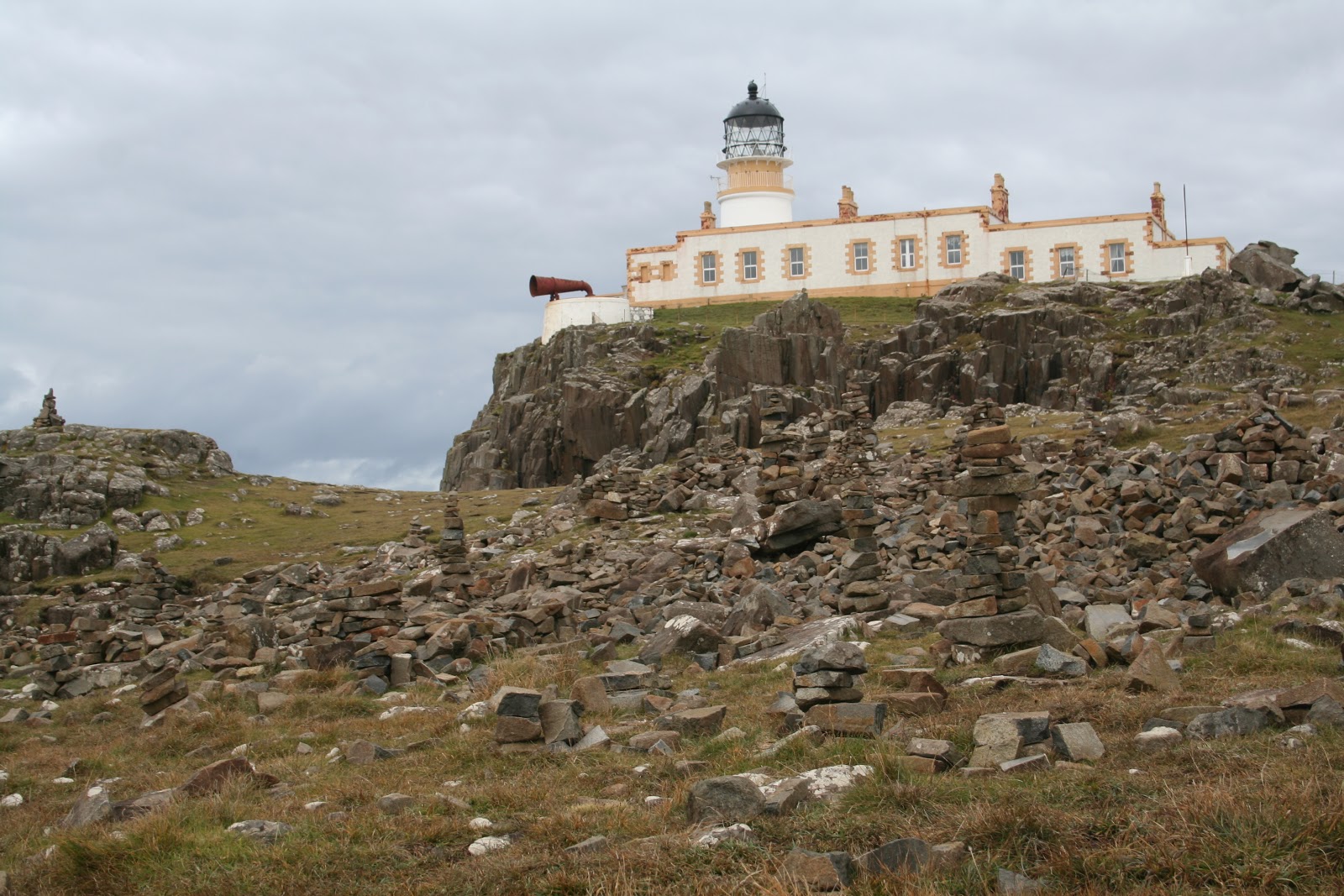
Next, I went to Neist Point in the Duirinish peninsula. The lighthouse here was dated from 1909. Nice red foghorn stood out amongst the white and yellow building. Can also see the old cable way that was once used to transfer supplies to the cottages and lighthouse from the end of the public road. Nice viewpoint to watch for seals and whales. None that day though. Too windy to see anything amongst the waves.
I drove the main road south to Kinloch forest and camped out here for the night. I woke this morning, excited to continue down to Armadale, to see the castle ruin and museum of Clan Donald. The clan my grandma's ancestors branch from.
Armadale castle was on a huge estate with tons of walking paths in the woodland and beautiful gardens. Some of the trees reminded me of home with all the multicolours of autumn. I visited the castle ruin first. It was built in the 1700's, but in the mid 1800's was destroyed by a fire and abandoned. Plants were growing on the walls and though some of the medieval stones could be seen on the ground, it was mostly all vegetation. It was really pretty, seeing nature take over that place. To the right side were estate offices, attached to the last wall of the ruin. Looking through the windows, I could see paperwork and coffee cups. Ha ha, yup, just looked like office space. Not too exciting.
Next I took advantage of the sunlight and walked around the gardens. Looking at the ponds and an old stone walled ruin where they did the laundry.
Lastly, I visited the Museum of the Isles. There was a library inside, where you could meet with someone who would help research your ancestors by using genealogy. That was really neat.
There were 6 galleries following 1500 years of history and culture of Clan Donald (the Lords of the Isles), the highlands and kingdom of the isles.
It tells of the origin of Clan Donald. Started by Donald, the grandson of Somerled (a Gaelic hero), who then named his decedents and followers MacDonald. Clan Donald is one of the largest clans of Scotland. It was a very powerful clan in its time. I learned of the battles between clans and land (looked like the Campbell clan and Donald clan really didn't get along), the Jacobite rising and falling, the English government forces impact on the clan, the tragedies, struggles and bloodshed of the people and the loss of homes through evictions, resulting in immigration to other countries.
I think the most horrific story was the massacre of Glencoe in 1692.
William, prince of Orange, was invited to take the throne, and had offered the Highland clans a pardon for their involvement in the Jacobite uprisings if they took an oath of allegiance in front of a magistrate by a certain deadline. At the time, James II of England was exiled in France and was hoping to return to reclaim the throne. The Highland clans awaited his permission to give their oath to William. Finally, James had given them permission and the clans gave their oaths. But, the message was sent in winter, when the weather was in bad conditions and was received by the chiefs only weeks before the deadline.
Some chiefs promptly gave their oaths, others didn't. The chief of Glencoe, Alastair Maclain, was one of them. He first went to Fort William, but was told the governor wasn't authorised to receive it. Given a letter of protection and a letter to receive the oath as he came to the governor in the allocated time, he went to Inverary. Winter weather slowed him down and he also was detained at a castle (as a ruse to delay him). Once in Inverary, he had to wait for the magistrate to return from a family visit for 3 days. Finally, he gave the oath, thinking all was well.
However, a senior member of the Campbell clan saw Maclain was late giving his oath and took advantage of that knowledge.Wanting to seek revenge on the clan, he found an accomplice (who wanted the downfall of the Highland clans), Master of Stair, to take them down. The Master of Stair persuaded William to sign an order to exterminate the MacDonalds of Glencoe by telling him of the irregularity of the oath, and that it's to rid the thieves in the valley.
A regiment of 120 men went to Glencoe. The Highlanders believed they were there to collect tax and the soldiers received the hospitable tradition of the Highlands. Unknowing of the real orders behind the visit.
38 men were murdered either in their homes (as Maclain was, in his bed) or trying to flee the valley. The woman and children were able to escape, but many died of exposure after their homes were burned. Some of the soldiers didn't agree with their orders and had either warned the people or refused to act. Such a sad story.
So much to take in, all the history of the highlands. But, I enjoyed learning, even if some of the stories were devastating.
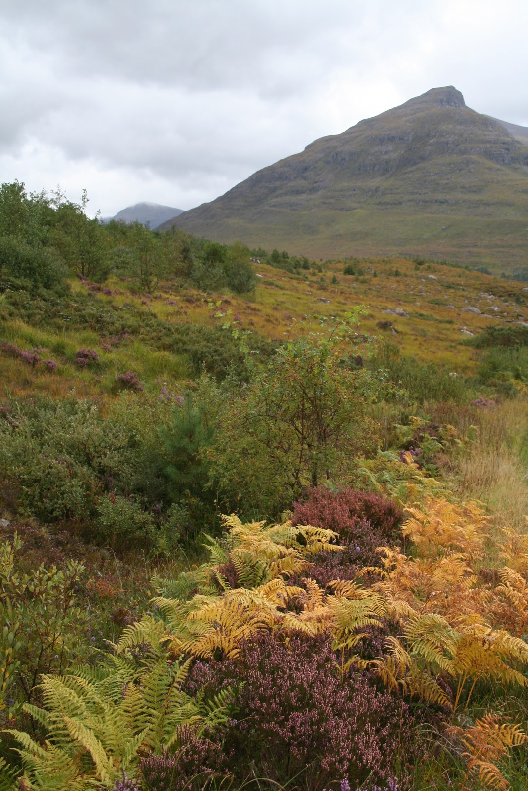
Now, I'm back in Kyle of Lochalsh treating myself to lunch. Next, I'll be heading north to Torridon. A place recommended by some other hikers I've bumped into.

Wednesday 19 September 2012

Glencoe & Fort William

The drive to Glencoe was lovely. I followed the coastal highway and passed a few rainbows along the way. Yes, it was raining. Again. But, at least the sun tried to make an appearance and as a result... rainbows!
As soon as I reached Ballachulish, I could see the change in landscape. Lush green rolling hills a plenty. Within 10 minutes, I was in Glencoe. I stopped at the visitor centre to pick up a couple walking maps then headed out.
I stopped at almost every layby, taking pictures and enjoying the scenery. What a gorgeous place. I fell in love with it. Even though it was dark, cold and raining, the beauty was overwhelming. Waterfalls all over the mountains and roaring streams from all the rain. This is the benefit of being here in autumn. The downside... very slippery and boggy while hiking.
There were many parking areas along the A82, and I stopped at one of the main ones. At The Three Sisters. 3 peaks beside one another, with deep valleys in between them. I got geared up to brace the cold, gusty rain and started on my hike. The valley I chose was between the last peak of the Three Sisters and Buchaille Etive Beag. It was full of little streams, lots of purple heather, tall green grass, moss and bunches of bracken. This is Scottish muirs. Such a beautiful site. I love all the purple heather, and occasional yellow and white flowers. Seeing that scattered over the rich variety of greens, can't help but tug at your heart. I didn't mind being soaked at all.
I followed the trail into the valley, then decided to skirt off up the mountain. It was extremely windy. The mountain had 2 summits (924m and 958m) and I hiked up in between them. I debated climbing the last 150 m to the top but thought, with all the gust I'd get up there, it would be very dangerous. I had the occasional gale almost knock me over as it was, sheltered in the rocks. So, I just enjoyed my view there and eventually made my way back to the car. I made a few more stops along the way and then looked for a place to camp for the night.
There was a small road that headed toward Glen Etive and I drove down there. It was a small, windy road but had lots of passing areas for other oncoming vehicles along the way. It wasn't a very busy road so I took the opportunity to take many pictures at most passing bays. Such a nice place. A river roaring alongside the road through the valley with Buchaille Etive Mor on my right side. A pyramid looking mountain. Passed a few areas with Red deer as well. Many bucks, and only 3 doe seen so far. Their quite large, those deer. Beautiful.
At the end of the road, there was a little gravel parking area and then a nice couple patches of grassy areas beyond it, perfect for setting up a tent. Right along the loch shore. The loch connects to the sea from here, so it wasn't good for washing. But it was no bother. Plenty of fresh water streams and waterfalls around. I was fairly sheltered at my camp, surrounded by mountains. Not much wind and it was so calm and quite. I had it all to myself. I set myself up and roamed around the area a while. After I had my dinner, another vehicle showed up. Three men had the same idea and they set up their tents not far from mine. I thought, why not say hello? It's just us 4 for the night...
I introduced myself and I met Sinclair, John and Russell. Sinclair and John lived in Edinburgh , while Russell was from Sheffield in England. They were having a weekend away from the city. They were very kind to me, offering me to join them for dinner and wine. I had already ate, but seeing how they had meat (and burgers at that!), how could I resist. My fruit and cracker dinner didn't compare to that!
We sat around the campfire and drank wine, sharing stories. Next thing you know, we drank all 3 boxes of wine and even a bottle of whiskey Sinclair had for a little nightcap. Ha ha ha, all 4 of us were a bit drunk, I have to say. We felt like a bunch of teenagers being so silly, stumbling around, even tripping over the fire! Oh dear. We had a blast though. Those guys were awesome!
I woke up the next morning sick as a dog. I don't like wine at all, and to drink that much the night before... *groan*. When I got out of my tent to see them, John had gone for a wander and Sinclair was looking not much better than me sitting in the chair. Ha ha, what a sight we were. Russell was walking around filming a bit, but he wasn't top shape either. We laughed at ourselves, reliving some of the moments of the night before, and the boys were thinking "we drank all our alcohol for the weekend on one night!" Not what they had originally planned! Lol, but they had a great time too. I stuck around for a short while when John came back from his walk, exchanged numbers and emails and then I headed off.
I planned to do some more hiking, but with the way I was feeling... As I said, the road was windy. Had to stop 3 times to be sick then decided to pull over and have a little nap to get the nausea to subside a bit. After an hour, I was feeling much better, and wanted nothing more than I nice warm shower. I drove to Red Squirrel Campsite and got a pitch there. I did some laundry and the nice European staff allowed me to hang it up in a washroom that was currently closed off. Was perfect. I got some directions for a hike nearby and planned to go up it the following day before I moved on. Seeing how I was in poor shape, I just napped, read my book, did a small walk, drove around here and there, and socialized with the campers beside me before calling it a night. Suited me fine. A few midges were out and about anyway, being near the river's edge.
After packing up the following morning, I went to hike up the Pap of Glencoe. As per the directions, I was to follow the trail, pass through 2 gates then go up a steep trail after crossing 2 streams. The path I was on was a logging road, that I had to veer off and cut through a wooded area up onto another logging road. Problem was, I didn't know if I should go left or right once out of the trees. My gut said right, as it went uphill, but I was curious what was left. Of course, my curiosity got the better of me and I went left. Not much to see really, but it did lead down toward Loch Leven. Wasn't long before I turned around. I found the trail that cut through my first gate, trudged through lots of mud, puddles and bog (trying to walk on the rocks I could find as some areas were deep) and then came to gate number 2. Great, now I just had to find the trail going up the mount. And I walked, and walked... and am I all around to the other side of it now? Where the heck is this trail after the 2 streams? There's streams everywhere!  The path I was on does go all the way around the hill, following power lines. But I didn't want to keep going on this path. I resolved and headed back. Once near the gate, I looked again for this trail. I've wasted so much time already... but, where the heck was it?! Then I realized, the trail was a waterfall. All the rain over the past month, had flooded the trail. Lol, I wasn't going to go up that! So, I figured I'd start my way to Fort William as I was bound to find somewhere else to hike.
And that I did. I took the loop to Kinlochleven and found a Greymare's Tail Waterfall trail (named after King Edward VII horse). I know what your thinking... really, another waterfall Vicky? Haven't you seen enough? But hey, why not?
As I followed the colour marked path, I ended up finding multiple trails forking in different directions. I picked one. Ended up climbing and came out in a stunning glen, full of flowers, heather, sunshine and a beautiful view of Loch Leven.
Sometimes, it's worth getting a bit lost. I hadn't seen this waterfall, but I found something beautiful all the same. On my way back down however, I did find the waterfall. Wasn't as grand as I was hoping, but the forest was really pretty.
Wasn't long before I arrived in Fort William. The town is quite small, mostly outdoor stores, a tesco (groceries), pubs and hotels. A few tourist shops and a visitor centre. About it really. Very small, but it was great! All the outdoor stores had sales! Had to look around. Fort William is popular because it's the end point of the West Highland Way trail, as well as the entrance to the biggest mount in the UK, Ben Nevis.
I then drove to the end of Glen Nevis, enjoying the landscape around me. The very end of the road had a little car park and I decided to sleep there in the car overnight. About 4 other people were doing the same. To soggy of a ground for a tent here. I slept quite comfortably in the front passenger seat. Amazing how you can adapt.
The following morning, I decided to walk the trail to Steall Waterfall. Regardless of the pouring rain. And the trail wasn't without a few obstacles. Some parts of the path, you would step across rocks over a stream... but the streams were rampant down the slopes, the rocks slippery and some even under the fast flowing rapids. I was very glad to have good boots and sure footing. Yes, I said sure footing. I'm not always clumsy. Only sometimes.
Once I got to the meadow, it was completely flooded. The path I was supposed to follow was thigh deep under water. I scrambled along the side of the hill amongst the vegetation. Nice thing about the heather, it forms a solid foothold.
The waterfall was beautiful. Finally! A true waterfall! Not just a small one from all the rain, but one with some height and width. A hut was on the other side of the river, but seeing how all there was to cross the river was a metal wire to balance on and two as railings, I figured I wouldn't even try with how slippery it was and with the roaring river. Wouldn't risk my camera getting wet ;)
A path also follows along the river and eventually would cross it to the Steal ruin, but I'd have to come back another time when the water level is lower.
Next, I drove to Braveheart Carpark to hike up Cow Hill. It's just under 300 m (almost 3 km walk), but would be enough to still have a nice view.
The walk up was an easy one, and more of the heather moorland at the top. So pretty. Unfortunately, the clouds were too low to see the mountain tops, so I didn't linger too long up there given how wet I was. The wind picked up a bit and I was starting to get chilled from being soaked to the bone for hours. So, I headed back down to the car park and made myself some soup there at the picnic table.
Next, I went to the visitor centre for hiking Ben Nevis. I bought a proper map and guide for the mountain and checked the weather forecast for the next day. It was going to be sunny in the morning, then rain in the afternoon. Lightening storm up at the summit in the evenings with a possibility of snow. So, I planned to head up first thing in the morning. I was hoping they would have a form I could fill out to let them know if I went hiking and they could check to make sure I returned ok (like when I was in Australia), but no such luck.
I decided to stay at Glen Nevis Caravan and Camping Park. Again, no buddy system there, but it was a big campsite. At least they had showers. I would need it for after my hike the next day. I settled in, made dinner and had an early night.
Next morning, I got up early to catch the sun. And it was a lovely day! So nice to have some dry weather. Many people were already starting the climb by 7:45 am. Off I went to join them along the Pony Track. The first 600m was easy going, climbing up the Red Burn valley. It levelled off a bit at this half way point, revealing a small loch (called Lochan Meall an t-Suidhe) with a bunch of Red Deer nearby. Superb views of the valley.
From here on, the path relentlessly climbs a zig-zag pattern through scree and around boulders to the peak. By 800m, snow was dusting the rocks. The higher I went, the more snow there was. Luckily, it didn't get very deep. It has been known for hikers to loose the path and end up getting too close to the peak's edges leading to fatalities. Especially along the Five Finger Gully.
The summit plateau flattened out a bit, much to my relief as I pushed through my wall already and was wearing out. At the summit proper, there was a metal hut, war memorial and a ruin of an old meteorology observatory from the late 19th century. The question I had, "why is the hut on the highest point in the UK made of metal?" Lightening storms are not uncommon up here and people use the hut as a shelter. Even to sleep in sometimes. However, I guess if you're daft enough to sleep in a metal conductor during a lightening storm...
I didn't stay too long at the summit. There was thick fog and low cloud so no view at all. Visibility was only about 150 m. I stayed long enough to have a snack in the hut, talk to a few people, then headed back down as I was sweaty and getting cold with the brisk wind.
The descent was easy going. Enough people had walked to the summit that you could just follow the trail of footprints in the snow until the path was obvious again. Funny, sometimes, coming down hill is more difficult than going up. My knees and legs were getting pretty tired of the descent.
On average, it takes 6-8 hours to climb the 17km height of 1344m. I did it in 6.5 hours. I was very proud of myself. And rewarded myself with a hot shower, warm soup dinner and a good read before falling into a blissful sleep.
Today, I plan to have a nice coastal drive to Mallaig before heading to Isle of Skye. Let my sore body rest!

Friday 14 September 2012

Oban & Isle of Mull

After looking around town for parking, I found free parking in a lot by the recreational sports centre. It was up on the hill from town, but I didn't mind. One of the first sites I was going to look at was up on the hill anyway. McCaig's Tower.
The tower was built in tribute to the McCaig family. There was a beautiful, well maintained garden inside and a great view overlooking the fishing village of Oban and the islands off in the distance. It was very quiet up there and I took a half hour just enjoying the peace. I loved seeing the ocean. And I knew I was lucky, as the sun had made an appearance. According to the locals, that can be a rare thing in this seaside town.
I made my way down into the village to wander the shops. Got a local map from the info centre for orientation. Of course, one of the first stops I did was to go into the chocolate factory. Had to buy a few to try. Hmmmm, and they were good.
I walked along the esplanade to Dunollie Castle. This castle was dated back to the 15th century and built by the MacDougall clan. It has long since been abandoned for Dunollie house just downhill from the ruins. It used to be bigger than what is now seen. There were 3 floors, a dungeon (which hasn't been found) a chapel and 2 great halls. A settlement of people would have lived surrounding the castle, tending crops, net fishing in the sea, tending cattle and fighting for the chief when needed. The 5th chief, John of Lorn, was a supporter of King Edward II against Robert the Bruce and as a result, did have the castle besieged. So, the castle had been restored a couple times.
I headed back into town, bought an adaptor to charge my electronics and batteries with the car's lighter socket, had lunch and then made my booking for a tour the next day on the Isle of Mull.
Instead of staying at the campsite, I drove south out of town and found a nice resting site along Loch Feochan. I made dinner and decided this would be a good place to wild camp. There was fresh water running into the inlet so I could use that for washing up. Worked for me. Also was able to find a few spots along the shore to sit and look out on the water.
The next morning, I parked my car at the rec centre again, and went to catch the Caledonian MacBrayne ferry over to Craignure on the Isle of Mull. I was picked up at the pier by my tour with Isle of Mull Wildlife Expeditions. My guide was an ornithologist (bird specialist) and had been running tours on Mull for many years. We had a comfortable van and more then enough binoculars to go around for wildlife watching.
We hadn't driven far along the Sound of Mull before finding about a dozen porpoise frolicking out in the bay. I've never seen so many together at a time. They are usually in smaller numbers. A great sight to see. Our guide, David Woodhouse, identified a bunch of sea birds and tried to explain to us how to tell the difference between a Shag and a Cormorant out at a distance. The Shag is slimmer and when it dives, it clears the water where the Cormorant only half clears it. Doesn't look quite as graceful. After watching a few out on the rocks, I could see what he meant. Sure wouldn't have picked that up on my own... takes a trained eye.
We then continued along the coast until David spotted an otter. A coastal otter. The coastal otter is the same species as the freshwater otters inland. Main difference (besides the obvious, one in the sea, the other in fresh water) is that the coastal otters are up and about during the day. The freshwater otters are more nocturnal. The sea otter in North America is a different specie all together.
Hmmm, so maybe I did hear otters in the river by my tent the other night in the Trossachs...
The otter was diving about and catching all kinds of things just off shore in the kelp beds. We were all excited to see him come ashore, shake himself off, eat a fish and groom before he scurried off for cover. Cut little fella.
We continued driving, keeping our eyes open but also enjoying the gorgeous views of all the valleys, rivers, coastline, craigs, waterfalls and wooded areas. We saw a few seals lazing on some rocks and 4 White-Tailed Sea Eagles. Two adults were resting on a tree branch and two juveniles were circling in the air. Saw many buzzards as well. But they weren't as impressive as the eagles.
David said we were very lucky to see 4, as they aren't as commonly spotted. He mentioned the best time to see birds of prey is after a rainfall and that they tend to fly against the wind. Using the wind to keep them stationary in the air for a good look around. Also, key spots to find the eagles were tree tops (well, duh) and up on craigs sheltered by the wind. No Golden eagles for us that day, but that's alright. Maybe next time.
Along the main roads through the mountains, we had a great panoramic view of 3 lochs in a glen. It really is a pretty island. So much to see.
The food on our tour was great as well. Homemade soup and sandwiches, with cake, tea, coffee and biscuits. I believe our guide said his wife made the food. Even though I was much younger than everyone in the group, we all got along well and I really enjoyed my time. David dropped me back off at the pier so I could catch the 5 pm ferry back to Oban. Once I arrived on the other side, I grabbed a sandwich for dinner and drove back to the same spot I spent the night before at Loch Feochan.
This morning, I head off to Glencoe. Looking forward to seeing this place, as it's been raved about!